Arcgis Enterprise Overview
ArcGIS Enterprise is a browser-based GIS platform for mapping, data analysis, problem-solving, and data sharing. It is the industry-leading geospatial solution.
Use Cases
Customers recommend Workflow Management, Collaboration, Sending & Publishing Communications, as the business use cases that they have been most satisfied with while using Arcgis Enterprise.
Business Priorities
Scale Best Practices and Improve Stakeholder Relations are the most popular business priorities that customers and associates have achieved using Arcgis Enterprise.
Arcgis Enterprise Use-Cases and Business Priorities: Customer Satisfaction Data
Arcgis Enterprise works with different mediums / channels such as Mobile.
Reviews
"...Enterprise is a comprehensive web-based platform that allows enterprises the ability to collaborate and share data from various sources as services...." Peer review by Mark E
Arcgis Enterprise, Store Locator Widgets, Loqate, GroundTruth, MetaLocator, etc., all belong to a category of solutions that help Location Based Marketing. Each of them excels in different abilities. Therefore, determining the best platform for your business will depend on your specific needs and requirements.
Popular Business Setting
for Arcgis Enterprise
Top Industries
- Government Administration
- Information Technology and Services
- Non-Profit Organization Management
Popular in
- Enterprise
- Mid Market
- Large Enterprise
Arcgis Enterprise is popular in Government Administration, Information Technology And Services, and Non-Profit Organization Management and is widely used by Enterprise, Mid Market, and Large Enterprise.
Arcgis Enterprise Customer wins, Customer success stories, Case studies
What makes Arcgis Enterprise ideal for Workflow Management?
Why is Arcgis Enterprise the best choice for Collaboration?
What makes Arcgis Enterprise ideal for Sending & Publishing Communications?
10 buyers and buying teams have used Cuspera to assess how well Arcgis Enterprise solved their Location Based Marketing needs. Cuspera uses 155 insights from these buyers along with peer reviews, customer case studies, testimonials, expert blogs and vendor provided installation data to help you assess the fit for your specific Location Based Marketing needs.
What's New in ArcGIS Enterprise 11.2


Peers used Arcgis Enterprise for workflow management and collaboration
Arcgis Enterprise Competitors


Arcgis Enterprise Features
- Low
- Medium
- High
| FEATURE | RATINGS AND REVIEWS |
|---|---|
| Analytics | Read Reviews (17) |
| Custom Reports | Read Reviews (27) |
| CAPABILITIES | RATINGS AND REVIEWS |
|---|---|
| Analytics | Read Reviews (17) |
| Custom Reports | Read Reviews (27) |
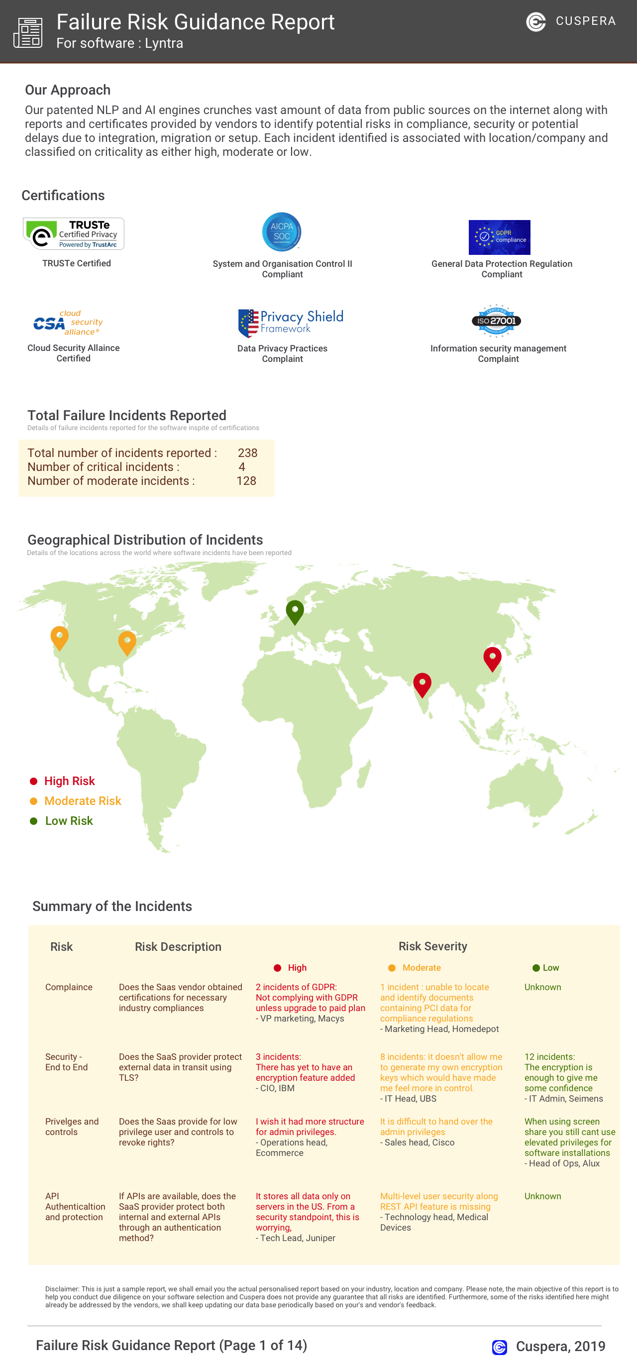
Software Failure Risk Guidance
?for Arcgis Enterprise
Top Failure Risks for Arcgis Enterprise
Esri. Profile
HQ Location
380 New York St., Redlands, CA 92373, US
Employees
1001-5000
Social
Financials
PRIVATE